


Why Is the Salty Tide at the Mouth of the Yangtze River Related to the High Dams and Large Reservoirs in the Upper Yangtze River?
The Yangtze estuary’s saline tide has changed significantly since the impoundment of the Three Gorges Reservoir.

Originally posted October 13, 2022 on the WeChat account “HeShanWuYan” (Rivers and Mountains in Silence; 河山无言)
Since early September this year, Shanghai, located at the mouth of the Yangtze River, has seen the salt tide intrude into the estuary. Of course, this salty tidal invasion is not new to estuaries around the world where rivers meet seas.
The Yangtze River enters the sea near the Chongming Island of Shanghai, and the 232-kilometer-long section of the river from Ebizui in Jiangyin County of Jiangsu Province to Jigujiao in Chongming Island is generally referred to as the estuary section of the Yangtze River. Here, the downward flow of the river and the upward tide of the sea intersect with each other: coming and going, moving back and forth. In its natural state, from December to April, when the river is at its driest, the salt tide invades and the saltwater flows upstream, usually with the highest salinity occurring in February. Records show that in the Qianlong period of the Qing Dynasty, there was a period "in February when the salt tide entered the city from Pukou, and the water in the city river was like a salt tide, which started to recede in twenty days".
Recently, it has been reported that the salt tide intrusion in the Yangtze estuary often occurs now from October to March each year. In fact, in the river’s natural state, the salt tide period in the Yangtze estuary would usually start in December. This is because the flow rate in the upper Yangtze River (for example, at the Cuntan hydrographical station in Chongqing at the upper end of the Three Gorges Reservoir) in October is still around 10,000 m3/s, so the river valley has not fully entered the dry period.
However, the saline tide situation in the Yangtze estuary has changed significantly since the impoundment of the Three Gorges Reservoir. According to “the Yangtze River Protection and Development Report 2009,” during the second phase of impoundment of the reservoir to 156 meters above sea level in 2006, more than 11 billion cubic meters of water was retained by the dam in September, resulting in the average flow rate at the Datong hydrological station near the mouth of the Yangtze River being 50% less than the multi-year average in September, and the average flow rate being 56% less than the multi-year average in October. More significantly, the salt tide came four months early, as a result.
From September 11 to 19, 2006, the concentration of chloride1 was greater than 250 mg/L at the intake of Shanghai Chenxing Reservoir (one of Shanghai’s four water supply reservoirs)2 and lasted a total of 108 hours. In general, if the concentration of chloride in the water body of the reservoir reaches 100 mg/L, it indicates that the water supply reservoir water had been affected by the salt tide invasion. In China, the concentration of chloride in drinking water generally cannot exceed 250 mg/L, and the concentration of chloride for industrial water is generally required to be below 300 mg/L.
During the period from October 9 to 17, 2006, when the second wave of salt tide invaded, the highest concentration of chloride at the intake of Chenxing Reservoir reached 1,476 mg/L, and lasted for 7 days and 22 hours, twice the conventional time, breaking the historical record of the number of days in which the concentration of chloride at the intake consecutively exceeded the standard from September to November. By the end of December 2006, the Yangtze estuary suffered an unprecedented total of six saltwater intrusions. In January 2007, despite the increased discharge from the Three Gorges Reservoir, the impact of salt tide intrusion on Shanghai's urban water supply was not reduced.
In the face of growing demand for water and the threat of salt tide intrusion, Shanghai started the construction of Qingcaosha Reservoir on Changxing Island in June 2007, moving it into operation in 2010. The reservoir has a capacity of 435 million cubic meters and can supply 7.31 million cubic meters of water daily. It is the largest of the four major water sources in Shanghai. The other three water sources and their daily water supply capacity are: Chenxing Reservoir, 2.06 million cubic meters; Dongfengxisha Reservoir, 245,000 cubic meters; and Jinze Reservoir, 3.51 million cubic meters. Among them, except for Jinze Reservoir, which is located in the upper reaches of Huangpu River, Qingcaosha, Chenxing and Dongfengxisha are all located in the estuary section of the Yangtze River and are therefore susceptible to salty tides, while Qingcaosha is the closest to the mouth of the sea and is more affected.
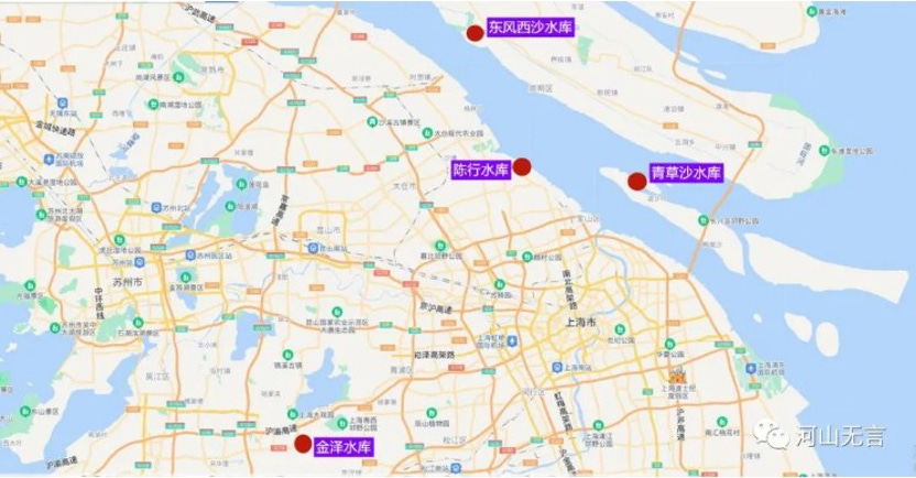
A map showing the location of Shanghai's four major water supply reservoirs.
Based on the monitoring data provided by the Shanghai Water Affairs Department, this year alone, salt tide intrusion has occurred at the Qingcaosha Reservoir intake since September 5, 2022, and at the Chenxing Reservoir since September 14. If the concentration of chloride at the reservoir intake, as a result of salt tide intrusion, exceeds the standard, the reservoir will be unable to draw water from the Yangtze; or the quality of the treated water will be affected due to high chloride concentration. In such a situation, the intake might be shut down and the water plant could rely on the reservoir’s stored water. It is said that with an effective storage capacity of no less than 387 million cubic meters, the Qingcaosha Reservoir can ensure normal water supply for at least 50 consecutive days without taking in new water. However, if the salt tide invasion occurs more often and lasts for a longer time, it will also create some impact on water supply.
Due to persistent high temperatures and drought during the summer season this year, the flow of the Yangtze River has been significantly reduced and the phenomenon of severe drought during what should have been the flood season has become obvious. As such, the salt tide invasion arrived much earlier this year, as early as August. According to the monitoring data by the water department, from August 10 to 12 this year, the outside of the sluice gates - at Sanjia Port along the Yangtze estuary in Pudong - measured a chloride concentration of 319 mg/L, 379 mg/L and 1,083 mg/L respectively, exceeding the standard of 250 mg per litres for domestic tap water.
The persistent high temperatures and drought, and the drastic decline of river flows this summer, resulted in historically low water levels in the cascade of reservoirs in the upper reaches of the Yangtze River. In most of the reservoirs, the water levels were even lower than the dead water levels.3 Under the circumstances, the reservoirs were unable to store the flood waters they normally would in the summer months. Instead, they have had to store water from September to October this year in an attempt to impound their reservoirs to normal levels. Because many high dams and large reservoirs in the upper reaches of the Yangtze River, such as Three Gorges, had no choice but to store water after the flood season, the water levels of the middle and lower reaches of the Yangtze River, in general, and the two large lakes, Lake Dongting and Lake Poyang, as well as other lakes that connect with the river, remain low, causing more frequent invasions of the salt tide in the mouth of the Yangtze from September to October as a result.
As seen from the water situation report issued by the Yangtze River Hydrological Information and Forecasting Center (see the figure below), in order to meet the annual schedule for impoundment of the Three Gorges Reservoir, dam authorities raised water levels. The outflow rate was much lower than the inflow rate, except for the period from October 3 to October 6 when the inflow dropped sharply, which inevitably made the situation of insufficient flow worse in the middle and lower reaches of the Yangtze River.
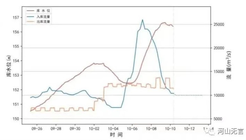
Changes in reservoir levels and inflows and outflows of the Three Gorges Reservoir from October 5 to 10, 2022 (Source: The Yangtze River Hydrological Information and Forecasting Center).
According to the report, as of October 10, the reservoirs in the upper reaches of the Yangtze have stored a total of 41.034 billion cubic meters of water above the dead level since late September. Among them, the reservoirs upstream of the Three Gorges Dam have stored 34.462 billion cubic meters of water above the dead level, an increase of 1.078 billion cubic meters over the storage volume on October 8. The cascade of dams on the Jinsha River have stored 25.62 billion cubic meters, an increase of 676 million cubic meters over the storage volume on October 8. The Three Gorges Reservoir has stored 6.564 billion cubic meters, an increase of 294 million compared with the storage volume on October 8.
What does it mean that the reservoirs in the upper reaches of the Yangtze River have already stored 41.034 billion cubic meters by late September of 2022? It is equivalent to 47.2% of the average annual runoff of the Min River, or 9% of the average annual runoff of the upper Yangtze River, or 27% of the average annual runoff of the upper Yangtze River from October to April. In particular, therefore, the impoundment of large amounts of water in the reservoirs in the upper Yangtze in September, in a normal year, is the most important factor influencing the reduction of flow in the middle and lower reaches of the Yangtze River.
Taking the real-time water situation at 19:00 on October 13, 2022, as an example, the water level of the Three Gorges Reservoir was 157.38 meters, which was still quite far from the impoundment target of 175 meters in the post-flood season. And on that day, the inflow rate of the Three Gorges Reservoir was more than 9700 m3/s, while the outflow rate was only 6,600 m3/s. Because of the impoundment of the upstream reservoirs, the flow rate and the water level in the middle and lower reaches of the Yangtze River, as well as the mouth of the river, will remain at a low level.
According to the data from “the Yangtze River Protection and Development Report 2009,” the Three Gorges Project and the central leg of the South-North Water Diversion Project4 have experienced the greatest impact on changes in the flow of the Yangtze River into the sea, where the discharge is reduced by 7.7% to 14% of the average annual flow from October to December. This can impact the Yangtze estuary in Shanghai as well as the water sources of the Huangpu, which will also suffer from salt water intrusion. Superimposing reduced flow of water from upstream with sea level rises due to global warming and ground subsidence5 in the Yangtze River Delta, the safety of Shanghai's urban water supply will face long-term challenges.
A salt tide occurs when decreasing freshwater flow in a river allows seawater to push inland, causing chloride density to rise and the river water to become salty. Chloride, in the form of the Cl– ion, is one of the major inorganic anions, or negative ions, in saltwater and freshwater. It originates from the dissociation of salts, such as sodium chloride or calcium chloride, in water. Although salinity is an important measurement in seawater or in estuaries where freshwater from rivers and streams mixes with salty ocean water, chloride concentration is usually used as an indicator. This is because salinity can be determined from chloride concentration since most anions in seawater or brackish water are chloride ions.
https://www.sixthtone.com/news/1011375/unseasonal-salt-tides-in-shanghai-threaten-its-water-supply
The Chenxing Reservoir is one of four reservoirs in Shanghai. The other three are Qingcaosha, Dongfengxisha and Jinze reservoirs respectively. These reservoirs were built to supply water to Shanghai.
The dead level is the lowest water level that is allowed under normal reservoir operation, also known as the “design low water level”. The situation occurs when water in a reservoir drops so low that there isn’t enough water to flow downstream from the dam.
The South-North Water Diversion Project (SNWD) draws water from southern rivers and diverts it to China’s dry north. The construction of two massive routes have been completed so far: one is the central leg, which draws water from the Danjiangkou Reservoir on the Han River, a major tributary of the Yangtze, sending it to Beijing and other provinces in the north via a 1,400 km open canal. Another is the east leg, where the water is taken from the lower reaches of the Yangtze River, near Yangzhou City in Jiangsu Province, and diverted to Shandong Province and Tianjin Municipality in the north. Based on the official data, about 675 million cubic metres of water from the Yangtze River is transferred to north China on the basis of the multi-year average. In addition, the Chinese government launched a new, mammoth Yinjiangbuhan tunnel project this July, which will drain water from the Three Gorges Reservoir to replenish water in the Han River, downstream of the Danjiangkou Dam, which itself is diverting Han River water to Beijing via the SNWD. The tunnel will take an estimated 10 years to complete and is expected to deliver an average of 3.9 billion cubic meters of water per year from the Three Gorges Dam to the Han River, and other places, once it is up and running.
Subsidence is the sinking or settling of the ground surface. It can occur through a number of processes. In the case of Shanghai, over-abstraction or excessive groundwater withdrawal used to be the main cause of ground subsidence. Now, with the construction of high-rise buildings and subways, a new cause of ground subsidence, leading to uneven subsidence, has been introduced to the city. Ground subsidence, regardless of the cause, leads to a relative rise in sea level, making it easier for salt tides to intrude. However, this effect takes a long time to be seen and depends on the effectiveness of ground subsidence control. Currently, it is mainly controlled by recharging the city's groundwater.